Measuring the local complementarity of population, amenities and digital activities to identify and understand urban areas of interest
Abstract
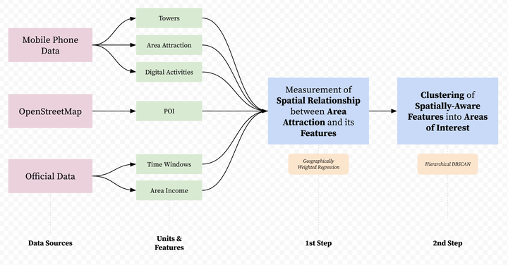
Identifying and understanding areas of interest are essential for urban planning. These areas are normally defined from static features of the resident population and urban amenities. Research has emphasised the importance of human mobility activity to capture the changing nature of these areas throughout the day, and the use of digital applications to reflect the increasing integration between material and online activities. Drawing on mobile phone data, this paper develops a novel approach to identify areas of interest based on the degree of complementarity of digital activities, available amenities, and population levels. As a case study, we focus on the largest urban agglomeration of Chile, Santiago, where we identify three distinctive groups of areas those concentrating (1) high availability of amenities; (2) high diversity of amenities and digital activities; and, (3) areas lacking amenities, yet, presenting high usage of digital leisure and mobility applications. These findings identify areas where digital activities and local amenities play a complementary role in association with local population levels, and provide data-driven insights into the structure of material and digital activities in urban spaces that may characterise large Latin American cities.
Francisco Rowe
Professor of Population Data Science
My research interests include human mobility and migration; economic geography and spatial inequality; geographic data science.